Archive Page 2

The new approach to the Spearhead Traverse

Backcountry skiers in British Columbia all know of the Spearhead Traverse. This is Canada’s “Haute Route” — a 35km trek crossing over 13 glaciers with about 2000m of elevation gain (and loss) that most people spread over 3 days (it can be done in a single thigh-burning day). Most of the route is between 6,000 and 8,000 feet. Access is easy: buy a one-way lift ticket for Blackcomb Mountain. At the end of the trip: ski down the runs on Whistler Mountain. That’s all that is easy about the Traverse. In between there are no escape routes. The steep glaciers make for breathtaking ski runs and long skin tracks up. If the weather is clement, the views everywhere are staggeringly beautiful. The coastal mountains are very rugged and dramatic.

Google Earth, Spearhead Traverse, Whistler, BC, Canada, showing significant gps waypoints
Significant GPS waypoints for the Spearhead Traverse
click for full-size

Until now, if you wanted to make the multi-day journey, you were required to carry all of your camping equipment. The fitness required, and the level of commitment has made the trip too daunting for many of us. Mountains make their own weather, and while it might be benign in Vancouver, in the remote high wilderness behind Mount Macbeth, the skier might be blinded by a whiteout and driving snow. An error in wayfinding would be tragic.

Now, the Alpine Club of Canada has envisioned 3 backcountry huts strategically and dramatically located along the Spearhead Traverse. More about this plan: 

The first of the huts is almost complete. On June 14, 15, and 16, I was part of the team helicoptered into the Kees And Claire Hut to assemble Barbara’s kitchen. More about the kitchen here. http://www.spearheadhuts.org/barbaras-kitchen/

Over the years, I’ve explored the fringes of this region. Some years ago a group of us camped at 2200m on the flank of Mount Trorey after crossing several glaciers from the lifts at the top of Blackcomb. In the summer we’ve hiked from Whistler up to Russet Lake, the location of the Kees And Claire Hut. This weekend I found there was something special about being able to linger in one place for a few days, and experience the vistas at different times of the day and  in different weather. 

Vistas! Yes, the views in all directions are amazing.

A panorama including the Kees And Clair Hut
Kees And Claire Hut
Please open full-size. It is the only way the mountain-images will achieve their grandeur

This hut is scheduled to open in the fall for the ski season. The easiest approach will be from the lifts on Whistler Mountain, then ski down the Musical Bumps to Singing Pass, and finally over Cowboy Ridge to Russet Lake. Edit: See the first comment to this post to find out how to make a booking for the Kees And Claire Hut.
Update — my Lisfranc foot injury

A short update on the consequences of my Lisfranc foot injury.

  • I injured the foot in March, 2018. The first operation was later that month. See my previous post about that.
  • In August, 2018 there was a second operation to remove the plate and screws and replace one screw with a ‘tightrope’ to hold the bones together.
  • After a month or so, X-rays showed some continuing collapse of the foot’s arch and I was tentatively scheduled for a third operation to fuze the bones to arrest the collapse.
  • Fortunately, over the following months there was no further collapse, and eventually the surgeon prescribed an orthotic insoles/inserts for my shoes, and insisted I buy a stiffer boot. If this works, I’ll not need the third operation.
  • In March 2019, the surgeon examined my X-rays and said that there has been no movement of my foot bones (no further deterioration) so no operation (for now). But if there is pain, I should call her. “May I walk and hike?” “Yes.” “May I run?” “No! No high impact activities for that foot.” “What about skiing?” “You can ski.” “What about telemark skiing (which is what I know)?” “No telemarking!” So, at 76 I will be learning how to use AT equipment and not raising my heel. I’m told that “AT” stands for “After Telemark.”

The worst part of those operations was maintaining my foot elevated ‘above the heart’ for several weeks. My inactivity has resulted in a huge loss of fitness, and an inexcusable amount of weight gain. So, I’m on new hiking boots, with expensive orthotics, and trying to exercise a few times each week.

Upgrade to our Mountain Weather Forecasting Resources

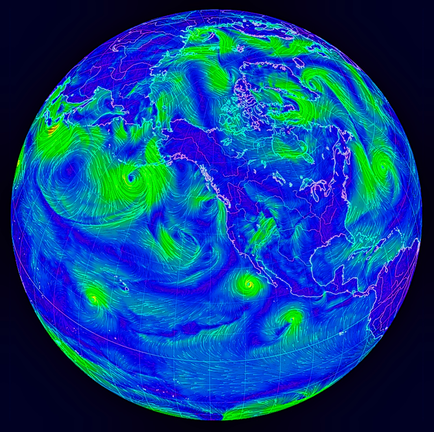
The Earth showing wind patterns
Link to Salish Sea Weather Forecasting Resources

It’s been three years since our Mountain Weather Resources web page has been updated. During this time some links have vanished and new resources have arrived. We maintain this information because there are few useful forecasts for mountain travellers.

Public forecasts are designed for urban areas and airports. It may be a benign rainy day in downtown Vancouver, but above 5,000 feet in the hills north of Squamish, backcountry skiers could be navigating the sub-alpine forests or high ridges and glaciers in a blizzard with fierce winds. With some thought, planning, and the amazing forecasting tools available, this is not a surprise.

Here, on the Canadian west coast the weather usually arrives from the Pacific Ocean and performs a dance with the mighty hills, valleys and fjords. Part of planning a trip into the mountains is knowing the land forms and anticipating how the weather systems will behave. Click here for Salish Sea Mountain Weather Resources.

Lisfranc foot injury — Hiking, chasing the mastodon

On Saturday, March 10, a small group of us were on a local mountain to visit the spectacular land sculpture of a life-sized mastodon.

Life-size mastodon at a wilderness location in Southern BC, Canada

Life-size mastodon at a wilderness location in Southern BC, Canada

Click here for more information on this amazing sculpture. Please follow that link because it is a wonderful story — but this article is about what happened to me that day. And no, I’m not going to reveal its location.

It was a lovely day, and after some time with the mastodon, we felt like doing a bit more off-piste exploring. And I made a serious error. In this blog you’ve read about my trading hiking boots for trail runners — that’s what I was wearing. Was it because I was on a familiar mountain, and not deep in the backcountry that made me careless? Whatever the reason, I found myself moving far too quickly through the thick underbrush. I must have put my foot in a hole, or slipped off a branch, but something hurt. By the time we regained the trail, I knew the foot was in trouble. Leaning on a ski pole, I limped off the hill. The next morning I took the foot to St Paul’s Hospital Emergency. First there were x-rays, then a CT scan, and the verdict was that this was a Lisfranc foot injury. Essentially the bones between the ankle and the toes which are normally held in position by tendons and ligaments, were pulled apart and out of alignment. I was provided with a mighty boot to support the foot, and a pair of crutches — and told not to put any weight on the foot. I was given the name of a specialist.

For my friends, and for the curious, I am prepared to show you what they did to me. If don’t like seeing the consequences of an operation, you may not want to continue with this article.

Continue reading ‘Lisfranc foot injury — Hiking, chasing the mastodon’

Frosty Mountains of Cypress Provincial Park

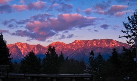
This was the view of the sunset on wintery Mount Strachan (1454m, centre) and the Black Mountain plateau (1217m, on the right) just moments ago. St Marks Summit is the bump on the left — a worthy destination and viewpoint when hiking the Howe Sound Crest Trail from Cypress Bowl in Cypress Provincial Park.

The Mountains of Cypress Bowl from Snug Cove, Bowen Island

The Mountains of Cypress Bowl from Snug Cove, Bowen Island

New Years Day Igloo — 2018 on Hollyburn Mountain

A decade ago my teenage daughters and our friends loved building igloos. I was surprised when I was requested to facilitate an igloo on New Year’s Day. Eight of us worked all day to build a 9-foot inside diameter igloo on Hollyburn Mountain, at 3020 feet, just up the hill from West Vancouver. Dave took a time lapse of the construction.


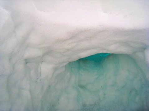
In the week that has followed, the weather warmed and there was lots of precipitation. Because of a local inversion, the temperatures at the altitude of the igloo meant that it rained… and then snowed. Today, January 9, I was in town, drove to the trailhead, and walked into the site of the igloo. Here is what I found.


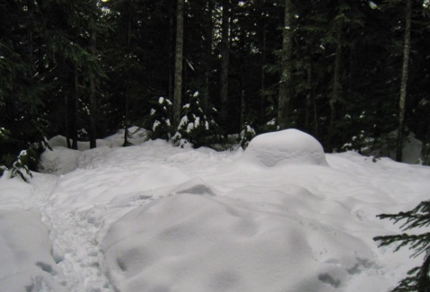
The igloo was a blocky mound in the snow. The catenary profile was gone.

When I arrived, all I could see of the igloo was a blocky mound in the snow. The catenary profile was gone. Had the igloo collapsed?

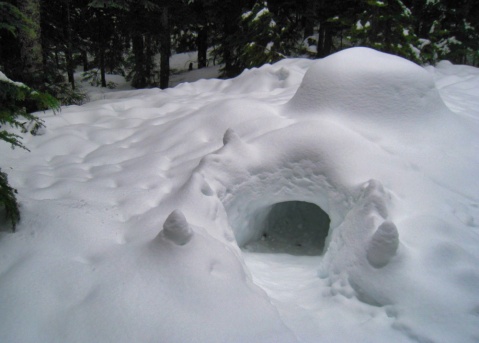
The top of the igloo looked very low. The door looked okay.

The door and tunnel was in good shape, and the ‘foundation’ had not sagged. But the top of the igloo looked very low

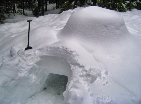
Cleaned up the igloo doorway in preparation for entering

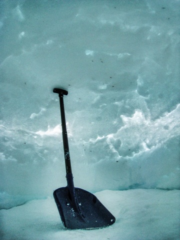
I cleaned up the doorway in preparation for entering. Note the size of the shovel compared to the height of the igloo.

Igloo entry tunnel - the roof of the igloo had not collapsed

As I crawled through the entry tunnel, I could see that the roof of the igloo had not collapsed

The igloo is slowly collapsing, like a balloon deflating

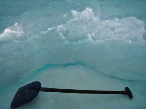
When I tried to sit on the floor of the igloo, with my legs in the entryway, I would bump my head on the roof. When the igloo was built, the top of the roof was 170 cm above the floor. Here, I cannot stand my shovel, and it is about 40 cm long. The igloo is slowly collapsing — like a balloon deflating.

The collapsing walls are restricting the size of the floor

The collapsing walls are restricting the size of the floor

There is a post about the plan for this igloo, and reports of our earlier igloos on the local hiking forum: Clubtread. Scroll the three pages of that thread for more details. The tool we use to make the igloo is Grandshelter’s Icebox®. We’ve made many igloos since we acquired it in the year 2000.

At this low altitude site, which is only a few hundred feet above the snow line, we don’t expect the igloos to last long. In a shady spot above 5000 feet, we might expect these structures to last for weeks or months.

A marvellous cold wet spring (2017)

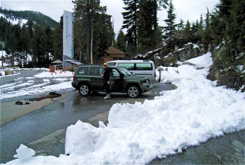
By late morning, Wednesday May 17, There was blue sky over Horseshoe Bay, and we thought we could see fresh snow on the local mountains. We took the rest of the day off and headed up the hill to ski. As we drove into Cypress Bowl we noted that there was plowed fresh snow along the side of the road. We parked at the top of the public paved road (3010 ft.) and marvelled at the recent dump of new snow.

Fresh Snow at ev. 3000 ft in Cypress Provincial Park parking lot

As we skinned up Mount Strachan the fresh snow became deeper. There were a few day-old tracks so the dump of snow arrived a couple of days ago.

We quickly climbed into a dense cloud. By the time we reached the summit ridge, the clouds had thinned and occasionally we glimpsed the disk of the sun.

With my ski pole, I measured the depth of the fresh snow: 16-inches!

16 inches of fresh snow on the summit ridge of Mount Stachan - May 17, 2017

This has been an unusual spring. The local temperatures have remained cold and we’ve had lots of precipitation. The size of the snowpack up on our hills is awesome.

The drone pictures and commentary in this Clubtread forum thread provide an interesting perspective of the current snow the conditions high up on Mt. Strachan: North Shore Cornices.

Cypress Beach

Sunday, May 7th was a stunner – deep blue sky, temperatures just above freezing, and the local mountains were making some of their own cloud. If you scroll back to last year at this time in this blog, you’ll see we were  walking up the hills around Cypress Bowl to find some snow to ski. Not this year! The snow is deep right down to the parking lot at the top of the paved road.

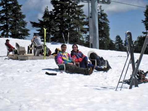
Last Tuesday I noticed that outside the lift shack at the top of the main ski lift (no longer in operation for this season) there was a small deck with a stack of plastic beach chairs (short legs). On Sunday there was a group of people using the chairs and enjoying the view and sun at Cypress Beach (elevation 4130 ft.).

Cypress Beach, Mt. Strachan, Cypress Bowl

Cypress Beach

on Mt. Strachan, Cypress Bowl

The snow on the mountains that form Cypress Bowl is deep even down to the parking lot at the top of the paved road.

The snow on the mountains that form Cypress Bowl is deep even down to the parking lot at the top of the paved road.

Mercury Rising

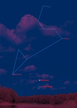
This morning, shortly after 6 am, I was outside watching the eastern sky as the stars above faded into the dawn. I was hoping for a rare glimpse of the planet Mercury. I did see it, and the tableau was interesting enough that I’ll be observing again tomorrow morning. Here is my simulation of what I expect to see so you can view the scene for yourself.

Mercury is the closest planet to the Sun, and in our sky it is usually too close to the glare of our star to be seen. We see its orbit almost edge on, so from the Earth, Mercury seems to dash from  one side of the Sun to the other. Sometimes it moves far enough away from the Sun so that it can be glimpsed in the sunset or sunrise.

Mercury at dawn 2016 September 29

Mercury rising on the morning of September 29, 2016
Click to see full size

The  Observer’s Handbook of the Royal Astronomical Society of Canada reports:

[Mercury] moves into the morning sky from the 20th to the 30th [of September 2016], reaching the greatest elongation on the 28th. This is the best morning apparition of the year for observers in the northern latitudes.

This image is a somewhat idealistic simulation. Today I found the sky was much brighter than the simulation, and the star-like objects that were visible in the brilliance of the pre-dawn sky were only Regulus in the constellation of Leo, and the planet Mercury. I recommend that you use binoculars to identify this part of the sky. Note: this is facing due east.

Even lower down than Mercury will be the 28-day-old crescent Moon.

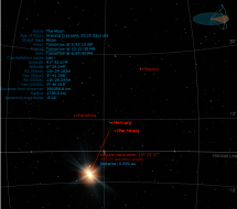
Astronomical Simulation of Mercury Rising 2016sep29, showing the distance from the Sun, the horizon line, and the position of the Moon.

Astronomical Simulation of Mercury Rising on September 29, 2016
click to see full size

Seeing the almost-new Moon, plus Mercury rising just before the Sun is the unusual tableau that will make it worth going out to watch.

At this point, the old Moon is only 15º away from the Sun (which is still below the horizon.) This sighting should be valid for any mid-latitude in the Northern Hemisphere. The local time (British Columbia, Canada) of the simulation is 6:30 am.

Burns Bog Plume

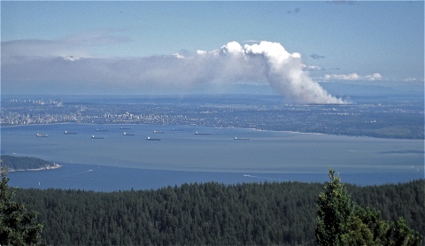
plume of smoke from fire in Burns Bog

Plume of smoke from the fire in Burns Bog
from the top of Mt. Gardner, Bowen Island

For exercise, on Sunday June 3, 2016, I walked up to the north summit viewpoint on Mount Gardner. There was a huge plume of smoke rising from the direction of the municipality of Delta. I learned later this was Burns Bog burning and there were about 100 firefighters trying to contain it.


Robert's professional sites:
Ballantyne and Associates
Governing

Jump to month

Blog Article Categories

RobertB on Twitter

Blog Stats

  • 173,358 hits