Posts Tagged 'Hollyburn Mountain'

9-Foot diameter igloo on Hollyburn Mountain

As the twenties decade approached, one of our old group championed the idea of making another igloo. The plan became to head into the forest about 9:30 AM on January 5, 2020, to build a 9-foot inside diameter igloo. We’ve done this before, but the weather, the quality of the snow, and the people assembled make each igloo unique. Because it involves several hours of teamwork, these events are somehow memorable.

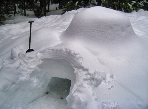
9-foot diameter Igloo on Hollyburn Mountain built on 2020jan5 with the Icebox from Grandshelters
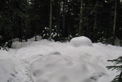
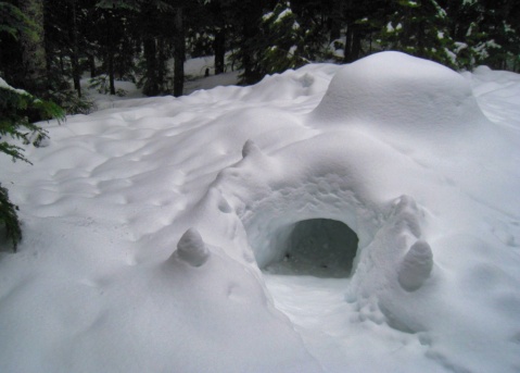
Site of 9-foot inside diameter igloo
with the entrance below the foundation of the igloo
click to see this panorama full size

It had been a wet week at sea level, but above 3000 feet in Cypress Bowl Provincial Park, above West Vancouver, BC, Canada, there was lots of new damp snow. This made for easy construction using the tool called The Icebox — a system that uses a plastic slipform for building the blocks of snow on the wall of the igloo.

We have been making igloos this way since our first one on January 23, 2000. More details about the new one are at the hikers’ forum, ClubTread. That post is part of a thread about several igloos we’ve made going back to the year 2006. The thread also includes some time-lapse movies of the construction process and a map of the location. Except for one day of rain, the temperatures up there have remained cold, and a huge amount of snow has fallen during the past two weeks. I would love a report on current condition of the igloo. If you plan to go, read that Clubtread post, and take a shovel.
New Years Day Igloo — 2018 on Hollyburn Mountain

A decade ago my teenage daughters and our friends loved building igloos. I was surprised when I was requested to facilitate an igloo on New Year’s Day. Eight of us worked all day to build a 9-foot inside diameter igloo on Hollyburn Mountain, at 3020 feet, just up the hill from West Vancouver. Dave took a time lapse of the construction.


In the week that has followed, the weather warmed and there was lots of precipitation. Because of a local inversion, the temperatures at the altitude of the igloo meant that it rained… and then snowed. Today, January 9, I was in town, drove to the trailhead, and walked into the site of the igloo. Here is what I found.


The igloo was a blocky mound in the snow. The catenary profile was gone.

When I arrived, all I could see of the igloo was a blocky mound in the snow. The catenary profile was gone. Had the igloo collapsed?

The top of the igloo looked very low. The door looked okay.

The door and tunnel was in good shape, and the ‘foundation’ had not sagged. But the top of the igloo looked very low

Cleaned up the igloo doorway in preparation for entering

I cleaned up the doorway in preparation for entering. Note the size of the shovel compared to the height of the igloo.

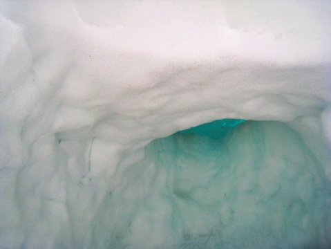
Igloo entry tunnel - the roof of the igloo had not collapsed

As I crawled through the entry tunnel, I could see that the roof of the igloo had not collapsed

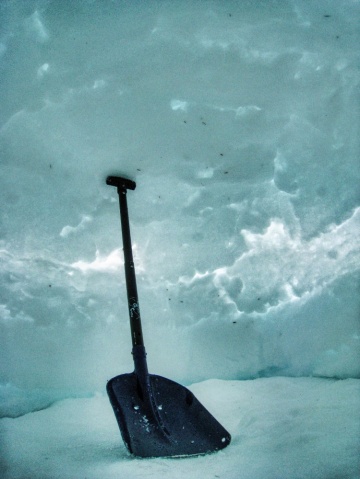
The igloo is slowly collapsing, like a balloon deflating

When I tried to sit on the floor of the igloo, with my legs in the entryway, I would bump my head on the roof. When the igloo was built, the top of the roof was 170 cm above the floor. Here, I cannot stand my shovel, and it is about 40 cm long. The igloo is slowly collapsing — like a balloon deflating.

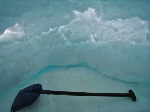
The collapsing walls are restricting the size of the floor

The collapsing walls are restricting the size of the floor

There is a post about the plan for this igloo, and reports of our earlier igloos on the local hiking forum: Clubtread. Scroll the three pages of that thread for more details. The tool we use to make the igloo is Grandshelter’s Icebox®. We’ve made many igloos since we acquired it in the year 2000.

At this low altitude site, which is only a few hundred feet above the snow line, we don’t expect the igloos to last long. In a shady spot above 5000 feet, we might expect these structures to last for weeks or months.

Sunday, Suddenly Sunny, Ski

After a month struggling with a virus, I was feeling better. And on Sunday there was a diamond-hard blue sky. Time to find some snow and ski.

Sunrise - departing Snug Cove on the ferry

Sunrise - departing Snug Cove on the ferry

There is snow high on the local mountains

No snow at sea level, but lots high on the local mountains

Access to Hollyburn Mt for skiers, snowshoers, hikers

Access to Hollyburn Mt. for skiers, snowshoers, hikers

It was cold at 1000 meters, and there was over a meter of snow on the ground. Compare this scene with the same place last year at this time: just before the Olympics.

That snow may look soft, but it is brutally hard.

Very hard snow, sparkling in the sunlight

Very hard snow, sparkling in the sunlight

Hole shows snow depth - at Water Boards, Hollyburn Mt.

Hole shows snow depth - at Water Boards, Hollyburn Mt.

Out of bounds on Hollyburn Mt.

Out of bounds on Hollyburn Mt.

Normally the best backcountry skiing on this hill is up there. We explored some of that inviting but icy slope and decided to return when there was something softer. It was a beautiful day and fun to be on snow again.


Edited post to add:

Compare the above snowpack to the huge amount of snow we found on a lovely February 24th, 2008

Cypress Provincial Park staff have cut a path to reach the trailhead on Hollyburn

Cypress Provincial Park staff have cut a path with steps in the snow to reach the trailhead on Hollyburn Mountain

Fresh Snow on Hollyburn Mountain

It is wet spring day at sea level, but above 3,000 ft. in Cypress Provincial Park it is lovely, snowing, and winter. (Earlier today, 2010 March 13).

The advantage of skiing on a local hill is that we still had time for lunch: a bowl of soup at Pho 993, and then dessert at Thomas Haas Patisserie (double baked almond croissant and an excellent Caffè Americano.)

Hikers’ Trail, Hollyburn Mountain

We went skiing in the rain today. I love the mountains, the woods, the fog – or being in the clouds… so we dressed for the weather. We were surprised at the lack of snow.  Normally, by January there is lots of snow in Cypress Bowl. This is the entrance to the Hikers’ access, a trail that leads to the summit of Hollyburn Mountain.

Hikers' trailhead to Hollyburn Mountain

Not much snow at the Hikers' trailhead to Hollyburn Mountain

The top of the groomed nordic runs on Hollyburn is known to the locals as the Water Boards. What we call the backcountry begins when we go above that. We were astonished to see that above the Water Boards there were still huge holes where water was flowing beneath the snow.

Above the Water Boards on Hollyburn Mt.

Snow conditions above the Water Boards on Hollyburn Mountain

In the picture, the top of the nordic run is the flat area in the top right of the picture. The sign is warning folks of the dangers of backcountry travel beyond that point. These holes reveal the current depth of the snowpack.

Lots of snow last January.

First Backcountry ski of 2009-2010 season

Today, from the ferry on the Salish Sea we could see that the tops of the mountains were in the clouds. Up there we experienced drizzle or heavy mist. There was hardly any snow until we drove into Cypress Bowl. Once on skis and heading up Hollyburn Mountain we were pleasantly surprised by the depth and quality of the early snowpack. It was a lovely day on the hill.

Winter on Hollyburn Ridge

The Dark Season has been particularly gloomy lately. We have received lots of precipitation. There is no snow at sea level, and not much below 1,000 feet. Above 3,000 feet there is now lots, and all of the upper trails on Hollyburn Mountain, in West Vancouver are above that. For days we had been watching a bubble of high pressure moving in from the Pacific Ocean. It arrived Monday night, and we planned to ski on Tuesday. I’m glad we did. That one day of blue sky was spectacular on the hill. (The pictures are thumbnails).

Backcountry trail on Hollyburn Mt.

As we begin to ski up the backcountry trail on Hollyburn Mountain, the high altitude old-growth trees are heavy with snow and ice. The temperature is just above freezing, and the trees drip on us as we ski beneath.

Since it is the middle of the week there are not many people on the path. Everyone seems in a good mood, and no one passes without a friendly greeting.

weather damage to trees

It looks as if this is a rough winter for the forest.

The heavy burden on the branches and the recent winds have brought down many branches and whole trees.

Looking down from Hollyburn Mt. to Vancouver

The hikers’ backcountry route meanders up and to the west of the groomed  commercial nordic area on Hollyburn Ridge. The top of the  nordic is known locally as The Water Boards. I’ve never known what that means. It is at that loop below us. Here the backcountry trail climbs an open swath in the forest and we have our first views of Vancouver and Georgia Strait.

A view of the Hollyburn Summit route

Higher up, the air is colder, and the trees are no longer dripping. The summit of Hollyburn is the dome to the right.

When I look at these pictures I don’t have the sense that we are climbing.  It is not very steep, but it is uphill!

View to the east and northeast

Up here it is possible to see the mountains to the east and some of the distant wilderness to the northeast.

I think the peak is Crown Mountain.

Trees snow and shadows on Hollyburn Mt.

It seems that lots of snowshoers are heading up to the summit.

We decide to find some fresh snow, and solitude, in the forest to the left of the route.

Icy Forest

That wide open swath didn’t feel like the backcountry.

Here in the forest, with the brilliant sun, the encased trees, and the dark blue sky, it is magic.

Glimpse people on the summit route

At one point I could look through the trees and glimpse the route to the summit. It was not far away and I could just hear laughter and squeals of delight. It sounded like a playground. Folks were enjoying the mountain.

Although the trees look as if they are plastered with snow, that is really ice-hard.

Ready to ski We arrive at a high dome. There is a couple of inches of wind driven powder over a hard base. The snow is sparkling in the sun and we have a fine view of Vancouver and the Salish Sea. The trees in this forest are spaced so that skiing among them, and finding the easier glades will be fun. To check the depth of snow, I plunged my avalanche probe straight down, and at 240 cm, there was no bottom. We took the skins off and skied down.


Robert's professional sites:
Ballantyne and Associates
Governing

Jump to month

Blog Article Categories

RobertB on Twitter

Blog Stats

  • 173,569 hits